Gila Hunnerd
September 12th, 2015
Canceled
Jeff Reese
is the coordinator for this ride.
He will handle any proposed route changes,
pre-rides, ride day sign-in/sign-out, etc.
Thanks Jeff !!!
is the coordinator for this ride.
He will handle any proposed route changes,
pre-rides, ride day sign-in/sign-out, etc.
Thanks Jeff !!!
This is fully unsupported and you will need to be self-sufficient in order to complete.
Please make sure to read all rules for this ride.
The rules are located HERE.
No more than 74 people allowed for this ride!
When: September 12th, 2015 at 8am
(Canceled due to more trail recovery required)
(Canceled due to more trail recovery required)
- 8 am sharp on bikes ready to ride
|
Gough Park, Silver City NM
|
What: Epic Mountain Bike Endurance Rides
- Course A : 60-miles, with 8.8K of climbing!
- Course B: 40-miles, with 5.5K of climbing
- Course C: 20-miles, with 1.8K of climbing
GPS Tracks:
- No warranty, express or implied, use at your own discretion.
- Garmin users can download directly into their supported devices from the Garmin Connect pages below. Be sure to a test “Do course” to make sure the track downloaded properly.
- You can also export the track to GPX from these pages, load into TopoFusion and then download to your GPS. Use this option for non Garmin users and those that above option dosen’t work.
- – Course A (60 miles) on Garmin Connect TBD
– Course B (40 miles) on Garmin Connect TBD
– Course C (20 miles) on Garmin Connect TBD
- – Course A (60 miles) on Garmin Connect TBD
- Go here to convert to other GPS formats
- Go here to download TopoFusion PRO Free/Demo
Course Descriptions:
Click here for annotated PDF map of the 1st loop.
Click here for annotated PDF map of the 2nd loop.
Click here for annotated PDF map of the 3rd loop.
Click here for annotated PDF map of the 1st loop.
Click here for annotated PDF map of the 2nd loop.
Click here for annotated PDF map of the 3rd loop.
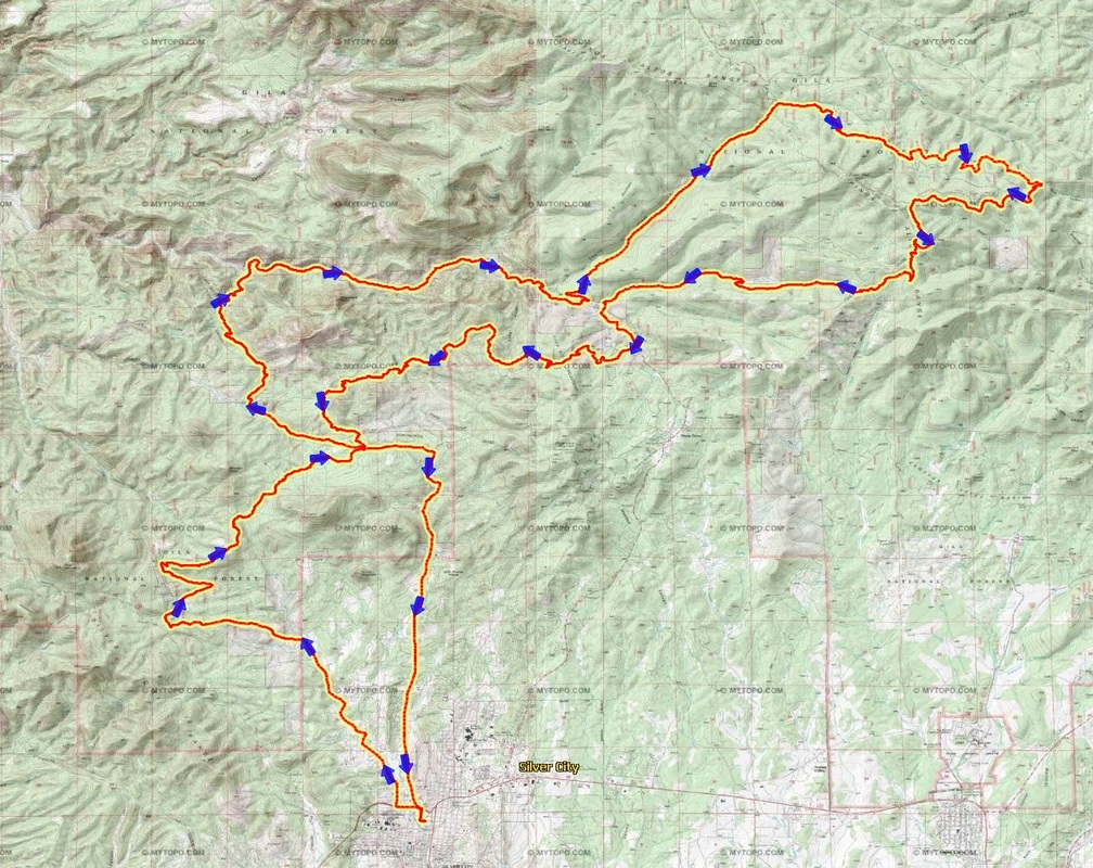
A course map (60 miles)
Gila Hunnerd 60 miler cue sheet
| Mileage (cumulative) | Abbreviations: CDT – Continental Divide Trail; USFS – U.S. Forest Service;R, L, BR, BL, S, TRO – right, left, bear right, bear left, straight, to remain on |
| 0.0 | West on 12 St from Gough Park |
| 0.1 | R – Grant St |
| 0.2 | L – Hwy 180 |
| 0.6 | R – Alabama St |
| 0.9 | becomes Cottage San Rd |
| 3.9 | BL – Bear Mtn Rd |
| 5.9 | R – USFS Rd 858 |
| 7.6 | R – CDT (single track before cattle guard) |
| 8.2 | CDT becomes double track |
| 8.4 | L – CDT single track |
| 9.9 | S TRO CDT @ post gate |
| 10.4 | BR TRO CDT after swing gate |
| 11.9 | L – Little Walnut Rd (20 milers go R) |
| 13.6 | R – USFS Rd 506 |
| 14.3 | R TRO USFS Rd 506 |
| 16.9 | USFS Rd 506 continues along Bear Creek (22 crossings) |
| 22.8 | L – Hwy 15 (40 milers go R) |
| 27.6 | R – USFS Rd 154, Signal Peak Rd |
| 30.0 | L – USFS Rd 855, Lockney Rd |
| 32.5 | R – CDT single track |
| 35.6 | BL TRO CDT single track @ gravel rd |
| 36.2 | BL TRO CDT single track @ trail jnc |
| 38.2 | X – old dirt rd TRO CDT single track |
| 38.3 | R – Little Cherry Creek single track |
| 40.4 | L – Little Cherry Creek Rd, USFS Rd 855 @ T |
| 42.4 | L – Hwy 15 (rejoin 40 mile course) |
| 43.4 | R – CDT single track |
| 44.0 | X – dirt rd TRO CDT |
| 44.3 | R – dirt rd TRO CDT |
| 45.4 | R – narrow dirt rd TRO CDT |
| 45.6 | L – single track TRO CDT |
| 46.6 | R – dirt rd TRO CDT |
| 48.8 | L – single track TRO CDT |
| 50.7 | S – TRO CDT @ gate |
| 52.1 | L – Little Walnut Rd |
| 58.9 | L – Hwy 180 |
| 59.0 | R – Grant St |
| 59.1 | L – 12th St |
| 59.2 | Gough Park |

B course map (40 miles)
Gila Hunnerd 40 miler cue sheet
| Mileage (cumulative) | Abbreviations: CDT – Continental Divide Trail; USFS – U.S. Forest Service;R, L, BR, BL, S, X, TRO – right, left, bear right, bear left, straight, cross, to remain on |
| 0.0 | West on 12 St from Gough Park |
| 0.1 | R – Grant St |
| 0.2 | L – Hwy 180 |
| 0.6 | R – Alabama St |
| 0.9 | becomes Cottage San Rd |
| 3.9 | BL – Bear Mtn Rd |
| 5.9 | R – USFS Rd 858 |
| 7.6 | R – CDT (single track before cattle guard) |
| 8.2 | CDT becomes double track |
| 8.4 | L – CDT single track |
| 9.9 | S TRO CDT @ post gate |
| 10.4 | BR TRO CDT after swing gate |
| 11.9 | L – Little Walnut Rd (20 milers go R) |
| 13.6 | R – USFS Rd 506 |
| 14.3 | R TRO USFS Rd 506 |
| 16.9 | USFS Rd 506 continues along Bear Creek (22 crossings) |
| 22.8 | R – Hwy 15 (60 milers go L) |
| 23.0 | S – TRO Hwy 15 @ Little Cherry Creek Rd (60 mile course rejoins here) |
| 24.0 | R – CDT single track |
| 24.6 | X – dirt rd TRO CDT |
| 24.9 | R – dirt rd TRO CDT |
| 26.0 | R – narrow dirt rd TRO CDT |
| 26.2 | L – single track TRO CDT |
| 27.2 | R – dirt rd TRO CDT |
| 29.4 | L – single track TRO CDT |
| 31.3 | S –TRO CDT @ gate |
| 32.7 | L – Little Walnut Rd |
| 39.5 | L – Hwy 180 |
| 39.6 | R – Grant St |
| 39.7 | L – 12th St |
| 39.8 | Gough Park |
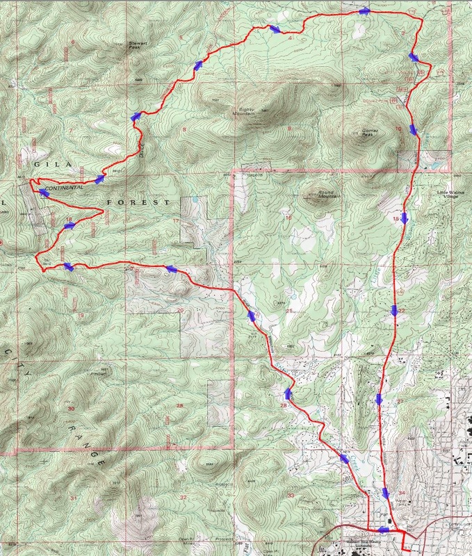
C course map (20 miles)
Gila Hunnerd 20 miler cue sheet
| Mileage (cumulative) | Abbreviations: CDT – Continental Divide Trail; USFS – U.S. Forest Service;R, L, BR, BL, S, TRO – right, left, bear right, bear left, straight, to remain on |
| 0.0 | West on 12 St from Gough Park |
| 0.1 | R – Grant St |
| 0.2 | L – Hwy 180 |
| 0.6 | R – Alabama St |
| 0.9 | becomes Cottage San Rd |
| 3.9 | BL – Bear Mtn Rd |
| 5.9 | R – USFS Rd 858 |
| 7.6 | R – CDT (single track before cattle guard) |
| 8.2 | CDT becomes double track |
| 8.4 | L – CDT single track |
| 9.9 | S TRO CDT @ post gate |
| 10.4 | BR TRO CDT after swing gate |
| 11.9 | R – Little Walnut Rd (40/60 milers go L) |
| 18.7 | L – Hwy 180 |
| 18.8 | R – Grant St |
| 18.9 | L – 12th St |
| 19.0 | Gough Park |
