The 4:25 to Santa Fe
Canceled
Chris Hereford
is the coordinator for this ride.
He will handle any proposed route changes,
pre-rides, ride day sign-in/sign-out, etc.
Thanks Chris!!!
is the coordinator for this ride.
He will handle any proposed route changes,
pre-rides, ride day sign-in/sign-out, etc.
Thanks Chris!!!
This is fully unsupported and you will need to be self-sufficient in order to complete.
Please make sure to read all rules for this ride.
The rules are located HERE.
No more than 74 people allowed for this ride!
When: Canceled
- 8 am sharp on bikes ready to ride
|
Sandia Pueblo Railrunner station
|
What: Endurance CX rides
- A route ~126 miles
- B route ~104 miles
GPS Tracks:
- No warranty, express or implied, use at your own discretion.
- Garmin users can download directly into their supported devices from the Garmin Connect pages below. Be sure to a test “Do course” to make sure the track downloaded properly.
- You can also export the track to GPX from these pages, load into TopoFusion and then download to your GPS. Use this option for non Garmin users and those that above option dosen’t work.
- Go here to convert to other GPS formats
- Go here to download TopoFusion PRO Free/Demo
Route Details:
The 4:25 to Santa Fe is a great mixed media combination of dirt roads and paved roads, with two great climbs. The full route, Route A, is 126 miles, with 47 miles on six dirt road sections, and the remaining 83 miles on pavement. Elevation gain for the full route is approximately 11,000 feet. The name comes from crossing I-25 four times on this long route. Route B is 104 miles, and skips the 57A/301 and C3 sections, but still does both climbs.
These dirt road sections vary from the long climb of Las Huertas, to near flat cruising on 301, to a very rough descent of Camino Cerro Chato (C3), to the brutal rough and steep climb up Old La Bajada, and a smooth cruise to 56C. The route ends at the Santa Fe Depot train station (Second Street Brewpub), and hop on the train and return to the start. Make sure you know the train schedule options! The 3:27 train is not really an option, but there’ll be plenty of time for beer and food at Second Street Brewery before the 8:12 or 10:07 trains.
Plenty of stores along the route to refuel, but the 47 mile stretch from I-25 and Hwy 22/57A to Santa Fe has no options, except the Santa Fe River at the base of La Bajada.
Ride starts at 8:00am at the Sandia Pueblo Railrunner station.
Bike choice? Narrow road bike tires will be rough and possibly unstable at the speeds you’ll reach on the C3 descent; 28’s or larger would be best for road tires. CX bikes or Mtb’s are best, but a heavy Mtb will make for a long day. The C3 descent will cause concern for pinch flats with tubes.
Route Description
A few of the miles of this ride are on PUEBLO/RESERVATION PROPERTY. Please be courteous and respectful, stay on the roads, and NO PHOTOGRAPHY. We are “allowed” passage, you could be stopped and questioned and turned back without discussion. Be courteous and respectful!
Route A and B
Exit the Sandia Pueblo Railrunner station and go north on Hwy 313 to Bernalillo. Turn right at the first traffic light onto E Avenida Bernalillo, and left on S Hill Rd. take this to 550/165 and turn right (east). Ride to Placitas and continue as the pavement turns to dirt, this is the Las Huertas Canyon climb. Climb about 7.5 miles and turn right onto 536 and descend to Hwy 14. Cross 14 and hit the first refuel point.
Go north on Hwy 14 to for a mile and turn left onto La Madera Rd. This turns to dirt at about 7.5 miles. Enjoy the scenery and STAY ON THE ROAD, all the way to the store at I-25 for the next refuel point. Go west from here and turn right onto ISR 84. Follow this to Hwy 22.
Route B Option
Ride north to Pena Blanca. The local market may be open, just as you enter town. Ride through the community and continue to Hwy 16, turn right and go east to the Tetilla Peaks Rec area turn. Go left. At 1 mile, turn right and head towards the Old La Bajada road climb.
Route A (cont.)
Go east on Hwy 22 up to I-25. Refuel options are the stores before you cross I-25. Continue across I-25 as the road becomes 57A and then 301. Ride this to Hwy 14. Turn left on 14, and after 3 miles, turn left onto Camino Cerro Chato. Turn left onto Pso Sudeste, and eventual right onto Red Rock Rd.
CAUTION: Stay on course in this section or you will find yourself in some ones front yard!
Follow Red Rock Rd to the pavement of Hwy 16/Galisteo Reservoir Rd. Turn left. Hwy 16 will eventually parallel I-25 and cross it on La Bajada Hill. Go west to the Tetilla Peaks Recreation Area Rd, turn right.
Route A and B
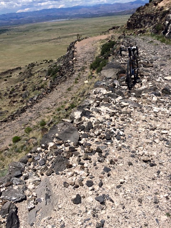
Go north, turn right at 1 mile and approach the Old La Bajada climb. You will cross the Santa Fe River before the climb, turn right to begin the climb. This climb consists of loose rocks and large rocks. Veer left at an intersection about .7 miles, and continue climbing. Don’t forget to enjoy the view as you ascend! The climb is only about 1.5 miles, but gains altitude quick. Check the view from the top, and ride to Santa Fe.
This next dirt road section is fairly flat and straight for about 6 miles, and then descends to Hwy 56/Paseo Real, turn left onto pavement. You will cross Hwy 599 (SF bypass) after a little over 3 miles. The first refuel option in Santa Fe is just after crossing 599, on the right. Turn left onto Agua Fria Rd. After a few miles on Agua Fria Rd, veer right onto Hickox St. After crossing Hwy 84, Hickox becomes Paseo De Peralta, continue to the Rail Trail, turn left and go to the finish at Second Street/Train Depot. Record your clock time here for the finish results.
Get a beer and burger or hop on the train!
The 4:25 to Santa Fe is a great mixed media combination of dirt roads and paved roads, with two great climbs. The full route, Route A, is 126 miles, with 47 miles on six dirt road sections, and the remaining 83 miles on pavement. Elevation gain for the full route is approximately 11,000 feet. The name comes from crossing I-25 four times on this long route. Route B is 104 miles, and skips the 57A/301 and C3 sections, but still does both climbs.
These dirt road sections vary from the long climb of Las Huertas, to near flat cruising on 301, to a very rough descent of Camino Cerro Chato (C3), to the brutal rough and steep climb up Old La Bajada, and a smooth cruise to 56C. The route ends at the Santa Fe Depot train station (Second Street Brewpub), and hop on the train and return to the start. Make sure you know the train schedule options! The 3:27 train is not really an option, but there’ll be plenty of time for beer and food at Second Street Brewery before the 8:12 or 10:07 trains.
Plenty of stores along the route to refuel, but the 47 mile stretch from I-25 and Hwy 22/57A to Santa Fe has no options, except the Santa Fe River at the base of La Bajada.
Ride starts at 8:00am at the Sandia Pueblo Railrunner station.
Bike choice? Narrow road bike tires will be rough and possibly unstable at the speeds you’ll reach on the C3 descent; 28’s or larger would be best for road tires. CX bikes or Mtb’s are best, but a heavy Mtb will make for a long day. The C3 descent will cause concern for pinch flats with tubes.
Route Description
A few of the miles of this ride are on PUEBLO/RESERVATION PROPERTY. Please be courteous and respectful, stay on the roads, and NO PHOTOGRAPHY. We are “allowed” passage, you could be stopped and questioned and turned back without discussion. Be courteous and respectful!
Route A and B
Exit the Sandia Pueblo Railrunner station and go north on Hwy 313 to Bernalillo. Turn right at the first traffic light onto E Avenida Bernalillo, and left on S Hill Rd. take this to 550/165 and turn right (east). Ride to Placitas and continue as the pavement turns to dirt, this is the Las Huertas Canyon climb. Climb about 7.5 miles and turn right onto 536 and descend to Hwy 14. Cross 14 and hit the first refuel point.
Go north on Hwy 14 to for a mile and turn left onto La Madera Rd. This turns to dirt at about 7.5 miles. Enjoy the scenery and STAY ON THE ROAD, all the way to the store at I-25 for the next refuel point. Go west from here and turn right onto ISR 84. Follow this to Hwy 22.
Route B Option
Ride north to Pena Blanca. The local market may be open, just as you enter town. Ride through the community and continue to Hwy 16, turn right and go east to the Tetilla Peaks Rec area turn. Go left. At 1 mile, turn right and head towards the Old La Bajada road climb.
Route A (cont.)
Go east on Hwy 22 up to I-25. Refuel options are the stores before you cross I-25. Continue across I-25 as the road becomes 57A and then 301. Ride this to Hwy 14. Turn left on 14, and after 3 miles, turn left onto Camino Cerro Chato. Turn left onto Pso Sudeste, and eventual right onto Red Rock Rd.
CAUTION: Stay on course in this section or you will find yourself in some ones front yard!
Follow Red Rock Rd to the pavement of Hwy 16/Galisteo Reservoir Rd. Turn left. Hwy 16 will eventually parallel I-25 and cross it on La Bajada Hill. Go west to the Tetilla Peaks Recreation Area Rd, turn right.
Route A and B
Go north, turn right at 1 mile and approach the Old La Bajada climb. You will cross the Santa Fe River before the climb, turn right to begin the climb. This climb consists of loose rocks and large rocks. Veer left at an intersection about .7 miles, and continue climbing. Don’t forget to enjoy the view as you ascend! The climb is only about 1.5 miles, but gains altitude quick. Check the view from the top, and ride to Santa Fe.
This next dirt road section is fairly flat and straight for about 6 miles, and then descends to Hwy 56/Paseo Real, turn left onto pavement. You will cross Hwy 599 (SF bypass) after a little over 3 miles. The first refuel option in Santa Fe is just after crossing 599, on the right. Turn left onto Agua Fria Rd. After a few miles on Agua Fria Rd, veer right onto Hickox St. After crossing Hwy 84, Hickox becomes Paseo De Peralta, continue to the Rail Trail, turn left and go to the finish at Second Street/Train Depot. Record your clock time here for the finish results.
Get a beer and burger or hop on the train!
